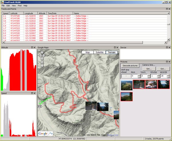
TrodTrack (Windows download) (Debian/Ubuntu download) is a PC/Windows/Linux program that allows you to view, edit and manipulate Global Positioning Satellite (GPS) data and to tag JPEG pictures with GPS latitude, longitude and altitude information.
TrodTrack displays the GPS information graphically in Google Maps form.
TrodTrack displays a graph of speed, altitude, and heart rate if the GPS information includes such data.
TrodTrack displays the GPS information in a list of "points" in "tracks". (A "point" being an individual location including latitude/longitude/altitude/time/etc. A "track" being a list of points.)
And TrodTrack can combine a camera's JPEG picture time information with known GPS points to embed ("geotag" / "geocode") the picture's location in the picture file.
TrodTrack reads and writes .gpx, .nmea, .kml, and .kmz formatted files.
The files, TrodTrack.exe and library.zip, are the program.
Note:
tz_trodtrack.ini and
trodtrack_pns.pickle (and backups of
them) in a directory under your Windows user
"Application Data" directory. You may
remove these files or leave them. No harm either way.
$ sudo apt-get install trodtrack{whatever version you have}.deb
Note:
/var/lib/trodtrack/, a symlink to the
program in your PATH, and a few other files in
scattered locations.
A clickable icon to run TrodTrack will be put on your desktop.
$ sudo apt-get remove trodtrack{whatever version you have}.deb
Note:
~/.trodtrack.cfg and
~/.trodtrack_pns.pickle (and backups of
them) in your home directory. They record your
current TrodTrack state and information. Do with them
as you wish.
TrodTrack is a normal program - the icon for which may be double-clicked.
TrodTrack takes optional command line options. They may be
displayed using the command line parameter
--help or from the menu choice, "Help |
Command line options...".
The menu choice "File | Open..." may be used to
open and view .gpx/.kml/.kmz/.nmea GPS track/location files or
.jpg/.jpeg picture files. Ambiguous input file names may be
given on the command line.
The menu choice "File | Save all points..." may
be used to save all or selected tracks/location data
currently opened in TrodTrack to a .gpx/.kml/.kmz/.nmea file.
.gpx
is the (preferred format) text file containing
all of the information (but some obscure .nmea
data) known to TrodTrack.
.kml
is a text format understood by Google Maps and
Google
Earth. Some information is not included in
.kml files.
.kmz
is a binary format understood by Google Maps and
Google
Earth. It is a compressed, binary version of
a .kml file. Some information is not included in
.kmz files.
.nmea
is a text format output by many GPS devices. Some
information is not included in .nmea
files.
TrodTrack's TODO list is very, very long. In particular, several menu choices are not functional (or even coded) yet.
TrodTrack will not affect your files except in these cases:
Scary information with respect to geocoding the picture files:
It is usually not possible to geocode a jpg file using exif data without "breaking" something. The exif data format was, ah, not thoroughly thought out. If TrodTrack must "break" something in the exif data, then TrodTrack is very, very conservative about how it's done. In particular, only two types of things are known to "break":
Each time TrodTrack geocodes an image file, a ".bak" version of the file is created containing the previous version of the file. If you tell TrodTrack to geocode your images more than once, though, the original image file will be lost.
Anyway, your best bet is to use copies of your original
pictures if you wish to push TrodTrack's "Geocode
pictures" button.
Under Windows, if you do not have Internet Explorer's Advanced, "Disable script debugging" options checked, TrodTrack - or more exactly, Google Maps' javascript code - may cause a trap to the Visual Studio debugger when TrodTrack starts up. If this happens, start TrodTrack with the --clear_map_position command line option and all will be well - until the problem randomly comes up again.
Neither net access is required for TrodTrack's operation, but ...
Windows: If TrodTrack finds an update, it downloads the new ZIP file to the directory/folder that TrodTrack.exe is in. TrodTrack notifies you about the new file after the download is complete.
Linux: Not implemented.
Trodtrack makes queries to http://www.geonames.org to fill in location names for points.
TrodTrack is a web "server" - able to take requests from browser/user-agent programs such as FireFox, Internet Explorer, Safari and Opera.
In fact, you may be able to see an "echo" of TrodTrack's mapping window pane in a browser program on your own PC that is pointed to: http://localhost:12399/.
Using this mechanism, your normal browser (or anyone else's) cannot control or affect TrodTrack as TrodTrack's internal communications is tightly controlled.
Linux note:
For technical reasons, TrodTrack cannot shut down
the browser window when TrodTrack exits.
    --copyright--   Copyright (C) 2008, 2011    Tranzoa, Co.    All rights reserved.

    This file is at:
    --url--         http://www.trodtrack.com/

    --version--     This is version v0.13.

    --bodstamps--
    March 13, 2008      bar     Initial version
    March 26, 2008      bar     web icon name right
    May 31, 2008        bar     --labels and --labels_near and --latest cmd line options
                                input nmea files with $GPGGA and $GPRMC records
                                various fixes
                                v0.02
    June 26, 2008       bar     v0.03
    June 26, 2008       bar     v0.04
    June 29, 2008       bar     move to trodtrack.com (without httpS 'cause of tz.net cert)
    July 5, 2008        bar     put label names in saved GPX files
                                DEL ^X cut
    July 6, 2008        bar     link to todo.txt
    August 31, 2008     bar     Linux version kinda working (needs firefox on the path and uses it externally to display map)
                                save selected points
                                v0.06
    September 2, 2008   bar     linux
    September 4, 2008   bar     v0.07
    September 9, 2008   bar     text clipboard working under windows, working in linux while program is running
                                linux picture icons (but tooltips don't show in Firefox)
                                v0.08
    September 10, 2008  bar     less crashing at startup with pictures
                                v0.09
    October 28, 2008    bar     kmlz
                                v0.10
    March 28, 2010      bar     update for python 2.6 and wxPython 2.8.10.1
                                v0.11
    March 20, 2011      bar     v0.12
    July 5, 2011        bar     v0.13
    --eodstamps--