Left late. Getting toward 8pm at the trailhead.
Went left at the cutoff, which is maybe 45 minutes to an hour up from the car parked outside the gate. I normally walk at about 3 mph, but not particularly fast up hills. Going up, I simply shorten the steps, gearing down. So, if you walk slow, the cutoff will be an hour and a half up the hill. If you really crank, you could probably get there in a half hour.
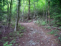
Picture of the cutoff:
So, taking that left turn, the trail leads up for a while on the same kind of stuff. Looks like a very, very old, simple logging road long gone bad from water running down it. Or sorta like the ground over a cable run. It’s not that, though. Not straight enough. To see what such ground looks like, drop off I90 at Highpoint just east of Issaquah and park outside the gate. Look around on the hill side of the road. You’ll find a trail leading straight up the hill all the way to the microwave towers. The key thing is “straight”. Incidently, that “trail” is the quickest way down from north Tiger Mountain. But it’s an unpleasant way to go up.
Anyway, back to the DHB trail: It goes up at a pretty fair clip. This time in June, there was still some water running on it. Nice to have the waterproof boots, but not enough water to be any problem for tennies. About double the distance to the cutoff from the road, there is a fork in the trail. The watery, rocky old-road trail cuts back to the left (west) while a more inviting trail continues up to the right. I took the east/right one. Above this fork, there is a large field of rocks such as are common on the I90 corridor hills. So, it looks like one fork goes around the rocks to the west, and the other to the east. Again, I stayed the course by going east.
After a while, the trail simply stops being the sort of trail it’s been since the road. It cuts to the left and climbs straight up an embankment in to the trees. Ooops. Here we are, back in the sort of area that I can lose a trail in. And, it’s starting to get dark. Oh well. Such is life.
So I zoom up this new section of trail. The whole trail is rather interesting in that it looks like it must get some traffic. It’s not overgrown. Odd, that, because the best thing about this whole trail is that it also has the feel of a trail where you’ll not see anyone else.
The treey section of trail keeps straight up the hill. After a while, there are some respites from the grind. In fact, below the top of a rocky hill, the trail heads back in to a sort of rocky bowl.
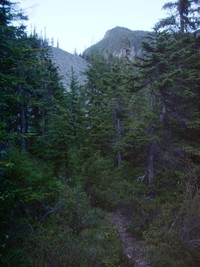
Eventually, the trail hits the rocks.
Which was a problem for me, given the time and light. There is one stack of rocks to indicate where to go across the rocks. I crossed one field. Then, all I could see were a couple of orange tags above me in the next rock field. Given that I’d not be able to see them in a few minutes, it seemed like a good idea to guzzle some drink and call it a day. Unsatisfying, that. Almost to the top of something, but forced to turn around.
Good thing I did. Only got off the trail a couple of minor times on the way back to the water-course / old-road-ish trail. Lucky for me that someone scraped the trail in many places to make it blacker and clearer. Whoever it was, must have done it very, very recently. Some brilliant woodsman, no doubt.
When I got to the Balcony cutoff, I thought: why not go up and watch I90 and contemplate life? 350 paces up led to contemplation point, so to speak. It was a nice contrast with the day’s daydream. The daydream for this hike was one I do now and then on trails in the I90 corridor: almost all humans suddenly die from some cosmic didease of something. Think Charlton Heston in the Omega man, without the zombies. It’s a good daydream for the I90 corridor, ’cause it makes the intense polluted waterfall sound of the freeway more bearable.
Back, under the moonless sky, Big Dipper grandly overhead through the trees.