Steep Speedy Hikes

It started as curiosity. What do GPS tracks say about the ratio of uphill and downhill hiking speeds?

It became graphs of all the hikes I’ve done since ’07 showing speed against the hike’s angle of slope.

Here are the average absolute slope angles on a per-track basis. If the dot’s high up, the hike was on a steep hill.

All hike speeds by track.

Yes, those high tracks before 2012 were steep. Mailbox Peak, Guye Peak, and Wagonwheel Lake, for example. Good stuff. A week after wobbling to the car below Wagonwheel Lake, I was merrily springing up the stairs at home.

Notice the laid back hiking in ’12 and ’13. … Sigh. … 2012 was a lost summer – lost working too much while the sun shone outside. The 2013 hiking season was spent in chemo-land. The cluster of flat hikes at the end of 2013 was me getting strength back by looping Maplewood.

Here are the average track speeds. It shows Scott’s bike a few times in the last couple years. The cluster of 5 kph tracks at the end of 2013 are the flat, Maplewood strolls mentioned above.

All hike slopes by track.

One of the slow speed hikes in late 2014 was up Adams Peak (Sri Pada) in Sri Lanka. Here are how the point-speeds on that walk distribute as a function of slope angle.

Sri Pada speeds by slope.

That hike’s graph really shows the difference between down and up-hill speeds. I “ran” down a lot, but you don’t enthusiastically race straight down 5000 concrete stairs.

Here’s the same sort of thing for Wagonwheel Lake:

Wagonwheel Lake speeds by slope.

As noted below, GPS points are noisy, any way you spin ’em. But the overall fit is OK.

Here are all the tracks’ points graphed as a function of slope.

All hike speeds by slope.

Bike ride speeds tower above the others. The near-level-ground points in the middle of the graph are, in fact, skewed to the left – downhill – to negative slope angles. They don’t look so in this graph for tech reasons.

Finally, here is a PDF containing scalable versions of the all-hike graphs above.

all_hikes.pdf

Note: These graphs were made from “hikified” GPS tracks. Points in a line between two points are eliminated by the “hikify” logic. That logic also combines GPS points near each other. But, even at a filtered, combined point scale, GPS data is noisy.

Python 2.7 scripts in the usual state of repair:

hikify.zip
gps_hill_speed_plot.zip

Little Hike in the Rain

In Ella, the big deals are things like a hill, a couple waterfalls, a tea factory.

I took a day to see a hill.

And got watered down while in the usual location: Off the trail.

It seems Costco’s nice, waterproof hiking shoes may not be completely waterproof. But, then, every shoe has a large hole at the top. Such holes in mine may have been a factor. Since I was pushing through thick, chest-high grass on a steep hillside, some of the water the shoes are so liberally soaked with even now, 12 hours later, may, just may, have leaked in fairly. And only one, big finger-cut on the grass, so not much blood to clean off. It was a very short hike, but a complete success.

I wonder what happened to the dog.

dog on little Adam's Peak

In a new place, one can notice separate worlds sharing a space, but only vaguely connected. In Sri Lanka, there are such human worlds. But a couple others become invisible wallpaper if you’re not careful.

Little dogs in the road. Lots of little dogs. Often sleeping. Oddly, with no apparent effort, avoiding being run over.

Little monkeys on roofs, wires and trees. Running around like feral kids. Apparently, they cause some damage. Pull apart roofing to get to food. Sneak in through windows to get to food. What happens to them when they can’t jump from power wire to tree?

Adam’s Peak – Sri Pada Temple

The hill country in Sri Lanka is webbed with roads curling around steep hills. Eventually, modern roads will be put in and trips that take a couple hours now will take a few minutes. Driving roads scaled to long English coastline fractal dimensions at speeds approaching 25 kilometers per hour – notice I didn’t say on which side those speeds are “approaching” – makes short trips complex experiences.

Above those hills looms a stand-alone hill that, in another place would be called “Dragon’s Tooth”. It’s English name is “Adam’s Peak”. Referring to the first dude.

Adam's Peak from afar Adam's Peak from underneath

Adam's Peak from Maskeliya Maskeliya from Adam's Peak

3000 feet up in 2.5 to 3.x miles. Most of the e-gain in the last third of the trail. The whole trail is stairs. All stairs. Nothing but stairs. Robust people do it in a couple hours. I took 3. Along with several guys hauling concrete and potatoes and video gear and whatever else is needed for the “season” to start tomorrow.

An easy part of the trail to Adam's Peak A harder part of the Adam's Peak trail

I stayed in another empty “hotel”. In a town named Maskeliya, not near the trailhead. That would be the last time I’ll book ahead, or even think ahead. This hotel was not only empty, but felt closed. The owner did try hard to make things OK. But I moved on. To a place chosen on the spur of the moment simply because a couple people in the Hatton railway station said it existed. Ella.

And write this in a comfortable, 1-person guest house there in Ella. Where ever that is.

Here’s a tea field between Hatton and Ella. Taken while standing between the rail cars, hanging out, seeing the sights. Catching tiny stickers from grassy stems brushing my hands as the train trundles by.

Tea field - many are the hills covered by tea fields

My first geocache

It was a sloppy job. Got kinda cold and wet up there. But I left my first geo-cache at the top of a hill, bushwhacked up from Bear Gap. It is one of the old ammo boxes from 25 years in the garage wrapped in reflective tape.

http://www.geocaching.com/seek/cache_details.aspx?wp=GC2EACX

Another hill near Bear Gap

And invented a new art form – web site coming soon … maybe … someday.

Behold, the “LimeriKu”:

There once was a gap named Bear,
who had a cache 6 thou in the air.
The cache it did shine
by flashlight at nine.
The car … … without spare.

Poetic license, ho!

TellAboutWhere

Spent the last few days exposing to the net some of the odd-ball GPS logic I’ve done for my own amusement in the last year.

Specifically, TellAboutWhere fronts for the alternate route finder, sparsifying, hikifying, and bikifying logic.

More to come, probably. For instance, I’ll probably expose distance measurement, which, if I recall, simply adds up the tracks’ distance between points after the tracks have been sparsified.

Under the hood, TellAboutWhere is kinda cool. The web page CGI script doesn’t do much. It just writes out the uploaded files to a data directory and keeps track of the “file sets” in Python pickle files.

A (soon to be cron started, screened) script runs on “spring” against the uploaded GPS files on the server, “asuka”. Other instances of this background processing script could run on other machines if there were ever any significant traffic to TellAboutWhere. The processing script simply looks at input file names and insures that the various processed, output files exist for them. If a particular logical process doesn’t create any track data – say, hikify finds no hikes in a track – then the processing script creates a zero-length output file as a place-marker so that the logic isn’t done again.

“File sets” are groups of files. File sets make it easy to combine tracks together for alternate route finding.

For alternate route finding purposes, files in a file set may be checked/included or not.

TellAboutWhere keeps itself from being overloaded by only allowing 8 files in a file set. If you upload more than 8 files, TellAboutWhere whacks, first, files that are unchecked, then files at random. Since the input files are stored by (CRC32) hash, duplicate files are automatically eliminated.

I Went Bush Climbing

Bush climbing, not rock climbing. The latter’s never gonna happen, what with the volleyball knee and all.

What’s “bush climbing?”

Imagine a hill without a trail.

A steep hill.

With bushes.

And little trees and such.

Well, if you are a couple weeks from limping around and thinking you’ll never walk right again, and if you’re the kind of person who can’t seem to stay on a trail, and if you spy what must be a shortcut to who knows where, and if you’re at the end of some side road up some hill, but don’t want to just wander on down and find somewhere else to go, what do you do?

You look up the hill, pretend that there are some clear spots in the foliage you can get through, pretend that the hill isn’t that steep, and you head on up.

And, after you’ve crawled up this thing by hauling yourself up grabbing huckleberry bushes, little Doug Firs, Cedars, and Vine Maples – yes, you too can dangle from some precipice, swinging your feet around looking for a place to put ’em while smiling encouragingly at the two huckleberries you’ve got your death grip on – then you can notice that the sun’s dropping behind McClellan Butte and you’re not in good shape.

Now what?

GPS to the rescue!

Well, anyway, even if it’s not really needed, I thought it would be fun to push the technology, sorta.

Called kids one by one. Scott called back ‘tween calls.

Me, “You at a machine?”

Scott, “Ha, ha. No!”

Me, “Ah, foo. I’m up a hill and want someone to find a logging road nearby for me.”

Scott, “I’ll check with Mike.”

Ring. Mike. In Boulder, CO, it turns out.

Back and forth, story and such.

Google maps.

Problem one: Google maps is unaccountably picky about how they take lat/lon. Order dependent. And they appear to take only a couple of exactly perfect formats. Takes a while to get straight. I’m kinda whacked so I don’t suggest a converter (as I know GM takes straight LA.decimal, LON.decimal. The GH615 shows DD.MM.thou format.). But, Mike figures it out.

Problem two: Mike says there’s a road north of me (where I came from) 400 yards. I’m thinking that’s a bit too near, but that 400 yards are horizontal yards, so maybe. Bothers me that at one time at the highest point I got to I can easily see 100 yards to the north. And that distance seems a small fraction of the horizontal distance I’ve covered.

Anyway, apparently, I must have either said the numbers wrong (by far the most likely possibility) or whatever format Mike found transformed ’em. Cause after I got back and generated this:

up_some_hill_to_east_of_mt_washington_01.kmz

which is too big for Google Maps, but shows this in Google Earth:

Google Earch snapshot of GPS track

it was clear that something went amiss. On the way back down I checked with Mike a couple times to see if I was, according to Google Earth, headed for the road. (I went to the east to miss the rock climbing part of the up-trip.)

Mike: “I have good news and bad news. The good news is you’re really moving. The bad news is you already crossed the road.”

New tech in action, folks. It’ll work better next time. I’ll try it tomorrow. I gotta go back there to find my glasses which I hope are along the no-vehicle road.

Good part, though, is that the advice from BCCC (Bush Climbing Central Control) – in Boulder, no less – take that NORAD – was accurate. If I’d continued south on the ridge I was on, I’d have ended up in Oregon, not at a convenient logging road, navigable at night with the flashlight.

At home, Google Earth did find a logging road south of where I had been. Close examination showed it to be at the bottom of a vertical drop of some distance. Going back the way I came (well, sorta), was the thing to do.

All in all, a very satisfying day.

Death Valley Walk

Sometime around ’bout the spring of ’79, it was, I was a ridin’ the bike through Death Valley on a Saturday night. After having a beer with some people from Luxemburg in the Furnace Creek Inn, I headed south. 11:30 at night found me pulled in to Badwater, the lowest point in North America.

What to do?

Walk out on the valley floor.

Blank, white flat. Check by taste. Salt.

The moon rose above the eastern wall and lit up the salt. Daylight, almost. Simply nothing was alive. Quiet. Very still. No bugs. Nothing. Just bright moonlight, bright ground and a long, long way to anything.

Rode south from there with no headlight for 50 miles until I hit the sack.

Wind the clock forward a few years. Scott’s 2 or so. Craig is 16, 17. We’re in the van and, for some reason, wandered by Death Valley. Full moon again. I say, “Let’s walk out from Badwater. It’s really strange.” We get to Badwater and find water. Lots of water. Seems like the whole valley floor is water. So much for our walk.

But wait! The water is warm. It’s ankle depth, maybe a bit more. What’s to stop us from walking out in it? There sure won’t be any sharp dropoffs in this pancake land.

So we did. I studied the sides of the valley, looking for signs of how far out we were. Half way? No idea, really. Hmmmm. Gleaming eyes from a coyote from the other side. Water climbed to knee height and the ground was getting pretty slick and squishy. Since Scott was sound asleep on my back it seemed like we had gone far enough.

We spent the night on the other side of the water – Lake Manly. We drove there.

Months later, I ordered a topo to find out the real situation. Yes! Looks like about a 6 or 7 mile walk across. That should be doable.

So, for a decade and a half I talked up the idea of walking across Death Valley. How many people can say they’ve done it, after all? Kids and life intervened, though. And Death Valley is not down the street, so the walk never happened.

But, in the late ’90’s Tom Boyle was at a show in Vegas, rented a car, and took a look. “Alex, you’re wrong. It’s not a flat, smooth, easy walk.” Tom described what sounded like the Devil’s Golf Course, an aptly named, rugged mess of land surface. I was so disappointed I didn’t even empathize with Tom’s disappointment.

So, another decade has gone by.

Badwater got a big, paved parking lot, a boardwalk, substantial pit toilets, the works.

Apparently, in Furnace Creek you can get a full-moon horse ride.

What’s the first few words of one of the signs at the big, paved Badwater parking lot? “The salt flats are always changing.”

This time I pulled in after a 14 hour drive at 11:30 under a cloud covered full moon sky.

No one there. I had kind of expected others to be trying this walk. Call it optimistic pessimism.

Toss extra Gatorades and Costco sport drinks in the day pack, put on shoes that can be thrown away, don’t bother checking the flashlight, and head west.

First half would look like this picture

Back pack on salt

if it were at the bottom of the sea. As it is, a flash picture can just show the surface. It can’t show the world. Even behind clouds the light is bright.

First input: Event horizon is 10 minutes. That is, if you see some surface change ahead as far can be seen, you will be there in 10 minutes. Such an horizon puts the lie to the idea that ship masts sinking on the horizon “prove” the absurd assertion that the world is round.

Second input: After a while, I looked up to see the mountains around the valley floor. The shapes and textures were very familiar. Apparently, they had not changed in 20+ years.

Third input: You can’t get lost. Well, duh. But, look at all the ways to orient. You cast a moon shadow. If you make a tube with your hands in front of one open eye, you still see the surface ridges shadowed by the moon. Stars are all over. Wind is blowing. Surface in many places is a flow. The floor is, after all, a large salty mud flat.

Fourth input: 3/4’s of the way over, the surface got a bit soft and slickish. And there were tracks. It had been much wetter some time. By stomping, I left tracks in only one or two small areas. Mostly, the ground may have sunk a bit under my step, but tracks? No.

Anyway, after an hour and 3 quarters, I hit stuff that threatened to turn in to what Tom found. Dang. If this ground were volcanic rock, it would be the shoe shredding stuff.

Press on.

My calculation was that if the valley were 6 or 7 miles across, then 2 hours, maybe 2.5 hours, should get me across to the west side road. At a hair under 2 hours the surface was quite unpleasant, and I began to think of what would happen if I twisted an ankle AND bongoed my other knee. Hmmm. Let’s say it takes 5 times as long to travel, at best. That puts me out on the whitest salt flat under a pretty good sun. That could get interesting.

So I was seriously considering spinning around. There’s really not a lot of purpose to the walk, anyway.

Then I stumbled on a small, dead bush.

On and on. Ah, what looks like it might be a road line.

10 minutes. No. They are big bushes.

5 long, long minutes. Bang. Road.

OK.

Drink a little.

Big decision: Do I wait for someone to come by and bum a ride back to the car? Or do I trudge back? Remember, I live in a world in which someone *may* come by. Heck, people probably come by there at 2 in the morning on Sunday nights in April every decade or so. So the odds are good. But, the sky cleared and the moon was free.

Anyway, whoever was coming by was probably hanging out around the turn a few miles to the south, waiting for me to get out of the road. So, it seemed like a good idea to just walk back.

I did.

Long walk. I got kind of tired at the end and strolled. Got back at 5.

As I drove away from Badwater, the moon went behind the clouds. I drove for a few minutes, gave up, pulled off and slept.

Nice walk.

Everyone should have a few Death Valley full moon crossings in their lives.

Blanca Lake

Summer and I saw the nice weather and headed up along Highway 2 past Monroe.

Hmmm. What’s Index? We looked. Tiny town with a cool name.

We kept going up the dead end road past Index, saw a sign about a trailhead, pulled an old trail map book out of the trunk, found the trail description, and thought, “Emerald waters, moderate to difficult, 2700 foot gain” … sounds good.

I gear up. Summer throws her red bag with a loaf of bread, some fake meat, and two small bottles of orange juice on her back, and we take off.

Or, more accurately, Summer takes off with a Youth of America bounce. I stomp after like Godzilla in flippers. Sheesh. Is this kid gonna hit a wall? Answer. No. The trail winds back and forth up a hill. It’s a very nice trail. This picture is not representative, though there are several rootie, Hobbittown looking spots on the trail:

Roots on the Blanca Lake trail

Eventually, the trail passes a little lake called Virgin Lake. Then the trail pops up along a ridge from which you can see Glacier Peak, the Northwest’s least visible volcano. And the top of the ridge is speckled with old peat bogs making artificial looking camp sites.

I found Summer at one of ’em talking with a couple of guys who were camped out. She’d probably been there for about 4 hours, given our speed differences. We all talked for a bit, having fun. Then the bugs got to Summer (“Hey, thanks for coming along. They aren’t bothering me at all.” says her empathetic Dad.), so we trundled on down the trail to Lake Blanca.

If you take this trail, don’t get discouraged when you start down the steep trail to the unseen lake. Yes, you hear water about 10,000 feet below. Yes, it’s a little hard to figure out why you won’t be going to that water. Yes, the lake may seem like it must be about another 4 miles away. But, trust me, it’s not too far.

And, the waters are “emerald”. I suppose. Anyway, they are a striking green that does not come through in this picture:

Blanca Lake

The flashlight, as usual, got us out to the car.

Nice hike. Summer figures to come back. The trail is variable, has a lot to offer. We probably hit its best time of the year.

Palisades Trail from Ranger Creek to Dalles Creek

Coming back from Sunrise up on Mt. Rainier few weeks ago, I picked up an athletic couple who had just popped out of the woods after some hiking. They said they’d done a loopish trail along a high ridge above the highway not far this side of the park entrance.

They said the trail was something like 14 or 16 miles. I didn’t like the sound of that milage so would have written it off. Except the guy left me their xerox of a map.

Inaccurate Palisades Trail map 
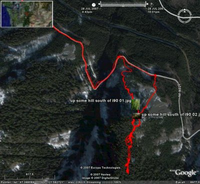
– (Click on the map image a second time to see a big version of it.)

And that map just sat in my “briefcase”. Taking room. Asking me at odd times, “Why not check this trail out?”

Well, today I did.

But, I forgot that they also said, “The map lies.”

Understatement. Perhaps their discription of the trail’s milage and the map and odometer reading on the road should have clued me in. The map has the trail at something a bit over a couple of miles. Maybe even 3 or 4 at the outside.

Reality has a different trail.

But, I didn’t remember that until later. Much later.

Got started so early that I didn’t even check the flashlight before setting off. No way could I be back in the dark today.

Read “The Khaki Boys – Over the Top” or some such boys-book from WWI times on the Palm on the way up. Do they still have war books for boys? Where the heros have stirring adventures and are always eager to get back in the fight? Where everyone around them is getting killed off, but where even if a hero gets blown through the air by a bomb and buried, he’s back fighting in a few days? Where our heros are saving the world for “liberty” against the “beasts”?

No. It seems that the States now fights for “the economy”. Which means a lot of good, important things. But, most of us probably have never really thought what those things are. Those things are probably similar to Dave Berry’s spoof of modern history books, in which every section women and un-white guys do “something important”. And, it’s hard to imagine someone willing to die for what seems like an extra buck an hour. But I digress.

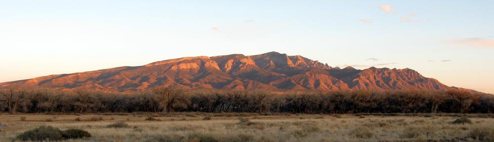
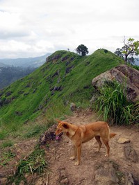
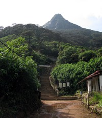
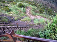
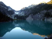
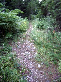
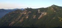
The trail, quite clearly a mountain bike trail, was smooth, regular, and easy to walk. Switched back a bunch going up the Ranger Creek area. The map is correct about that part. Got to the end of the switchbacks. Seemed like a couple of miles, both from distance and from time. Shot the first picture from an off-trail lookout.

Looking up White River valley from Palisades Peak

Now, according to the map, the cutoff for the dark, black Palisade Trail should have been a tiny distance away from that lookout.

Nope. Not there.

Looked at my watch. Going more slowly than I thought, apparently.

Looked at the terrain.

Hmmm. Looks right.

Where was that cutoff?

What to do?

Down toward the bottom of the hill there was a fork in the trail. I had taken the left one. Maybe the map was off and I should have taken the right one. … No. The terrain says that I’m at the right place. There were, I thought, more switchbacks than the map indicates, but that’s not enough to wonder about.

What to do?

I kept going up the hill, directly away from the road. Long, relatively straight section, matching the map’s description of the trail beyond the hand-written Ranger Peak. I figured “Ranger Peak” was the lookout.

At the east end of this valley, the trail started switchbacks again, just like the map had it. I didn’t like the idea of going up to a logging road and coming down the same trail I came up, but there it was. Nothing much, it seemed, I could do about it.

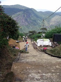
Got to a “top”. An open-sided cabin! With a dry water pipe coming out of the ground. Lifted it and heard a loud scraping sound. Funny water? No. It was a mountain biker coming down a trail to the cabin skidding to a stop a few feet from me.

He said, “We saw a sign at the top saying, ‘Highway, 7 miles.’ We’ve probably come down 2 miles.”

That seemed about right according to my watch and the Palm’s battery depletion. That put me 5 miles or so up the hill in a couple of hours or so. I was fuzzy on when I had left the car.

And…

At the cabin, there were 3 trails. One, down. That was the trail I had come up. Another, up. That was the trail the bikers (there were 6 by the time I left) had come down. Another was clearly marked as Trail 1198, the Palisades Trail.

But, all logic, terrain and time put us on the Ranger Creek trail just below the “15” on the map. There should be a logging road 1 or 2 hundred yards to the west of us. That didn’t feel right.

Well, perhaps I should have paid attention to the fact that the map also had trail 1167 running under Snoquera Falls. Trail 1167 would be the trail that disappeared under those falls, as I had found out another time when I’d stopped climbing straight up the hill toward the Palisades Trail that, at the time, I didn’t know existed.

Anyway, I was still desperately trying to make the map fit reality. Ah, such a naive belief in the truth of maps.

What to do?

I remembered the couple’s milage figure – roughly. But how could that nice, straight trail possibly be so long?

Several hours answered that question.

The trail is not straight.

In fact, There is one section of the trail that seems to run roughly where the logging road 7250 is. That is, you go out to the 5089 elevation ridge above the highway. Then you come back to cross the creek not far from where 7250 crosses it. Needless to say, it was not cheering to be walking in the opposite direction from where I needed to go … with no end in sight and the sun going down.

In the end, it appears that the real trail, perhaps rebuilt for mountain biking, follows the lay of the land. Always slightly descending. Following the contours from NE to SW and back and forth and back and forth until it piles up those miles.

It was a nice trail. Well drained and smooth, though slightly bowed from bikes.

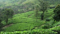
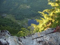
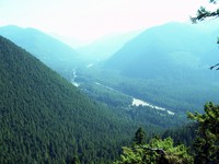
And, it’s always fun to stand on lookouts and stare down, way down, at things like roads and runways.

Runway?!?

It'll take Sky King and his niece Penny to land here!

Yeah, from the trail, you gotta wonder about that runway. Kinda tight. Not likely to be windy, though, deep in that valley.

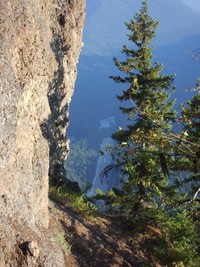
So, after the sun had dropped well below the hills, I got to the map’s “Loose Rocks”. Misleading words, those. There are some loose rocks on the trail. But nothing to write home about. Bikers would not like them. But, then, bikers would not like 20 foot wood ladders either. Nor multiple, 30-foot-long switchbacks. And, that’s what you find below “Loose Rocks”. It’s a steep hill.

It was dark at the bottom with the road within hearing. I went along the trail to the Boy Scout Camp. There, I found a sign saying “Ranger Creek 2 1/2”. What! No way. I went down to the road, walked along a trail that follows about 50 feet from the road for a while. Found a trailhead and wondered whether it was the one I left from and the car had been towed off or something. Logic said no. Walked further along the road.

And karma was with me.

A couple of guys in a big pickup with motorbikes in back stopped and asked if I needed a ride. Yep. Even if it was maybe 500 yards. It was worth it. I was dragging. A tiny breakfast and 3 bottles of Gatorade just don’t do it for a hike over 10 miles with plenty of altitude gain.

Should you take this hike?

Why not? Just don’t pay any attention to the map.

And do take it from Ranger to Dalles, SE to NW. Not the other way.

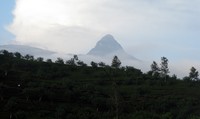
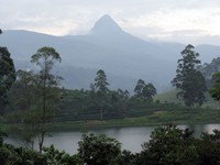
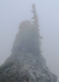
And do it on a day when the mountain is not faded in to the sky. From the ridge you see the top half.

And, maybe you’ll be able to bum a ride back to your wheels when you get back to the highway.

Dirty Harry’ Peak

Well, I suppose that it’s ’cause the trail is not far to get to that I keep coming back to it.

First thing: This is not a particularly good trail. It’s in the Mt. Si class of trails going up. Boring, really. Not much to see. One or two little lookouts far above I-90 on the way up. It’s about 45 minutes to the cutoff to the Balcony (if you’re reading an eBook on your Palm). And, another 45 minutes to a fork in the trail.

At the fork you can keep going straight to the east or you can switch back over the soggy ground and continue up the relatively steep trail to the west. This picture was taken pointing level, so you see that it’s a relatively steep trail.

Dirty Harry's Peak trail

The last hike before this weekend I’d continued east. Turned around from lack of sun. Good thing.

Yesterday, Saturday, I left much earlier and kept at it. And at it. Up above a little lake. The “trail” eventually peters out below the last section of rock near the top of a series of hill tops making the trail’s bowl to their west. In a rare state of reasonableness I looked up at the last few hundred vertical feet and said, “What am I doing here? If I get to the top of this thing, I’ll want to go along the ridge to the top of the highest of these peaks. Why?”

It was a hard question to answer.

I headed down.

But not without first eyeing the east end of Mailbox Peak and wondering, “Hmmm. Would it make some kind of sense to go overland to Mailbox. Then go down the Mailbox trail and hustle a ride back to the car?”

Luckily, it did not.

And I did not head down the northern side of all this stuff to Granite Lake where I figured I could pick up the old logging road leading down to the Middle Fork of Snoqualmie road. And bum a ride back to the car.

That “old logging road” is the one that goes up to the stange little building atop a mountain, the “Our welcome mat is always out for you” building. From the side of the hill I was on, I could not see that building, btw.

Anyway, Saturday I was low on Costco Sport Drink and hadn’t eaten much breakfast. End of hike.

Sunday: Oh, what the heck. Let’s see what’s to the left at the fork.

Apparently, what’s to the left is a long haul up to a hill that may or may not be named Dirty Harry’s Peak.

Getting to the bottom line: I read a book.

But, after slogging to the top, I found too very nice feelies:

  1. Coming around a bend near the top I looked directly across at the “our welcome mat is always out for you” … whatever it is.

    Strange building at the top of a mountain at the end of a logging road

  2. At the top you walk up through some scrub trees and, if you’re reading your eBook too intently, you can take a big step down. Just about staight down in to Granite Lake. Nice drop.

    Strange building at the top of a mountain at the end of a logging road

And, at the top you’ll find that you can’t easily zing over to the east end of Mailbox. There’s this little 100 foot drop to deal with. You could always skirt around below the hill top. Or you could bring a rope, double it around a tree or something and rappel down. But, why? Anyway, maybe someday I’ll take the old, old logging road up from Granite Lake and then sort of bush-whack to the top of Mailbox from the north side. Seems like it would be kinda fun. Maybe surprise someone there. “Oh, just passing through.”

So, this weekend was all Dirty Harry.

I suspect that I won’t be back.

Want a view that’s close-in? Rattlesnake Ledge.

And, if you insist upon doing Mt. Si, take the trail up from Little Si. It’s not marked, but you can feel your way off the Little Si trail to go up the main hill. It’s the only way to go up Mount Si. The main trail feels (to me coming down in the dark, twice now) raggedy and over-trodden and meandering. The trail up from Little Si softly and quickly goes up through a steep forest. Pleasant.