Bush climbing, not rock climbing. The latter’s never gonna happen, what with the volleyball knee and all.
What’s “bush climbing?”
Imagine a hill without a trail.
A steep hill.
With bushes.
And little trees and such.
Well, if you are a couple weeks from limping around and thinking you’ll never walk right again, and if you’re the kind of person who can’t seem to stay on a trail, and if you spy what must be a shortcut to who knows where, and if you’re at the end of some side road up some hill, but don’t want to just wander on down and find somewhere else to go, what do you do?
You look up the hill, pretend that there are some clear spots in the foliage you can get through, pretend that the hill isn’t that steep, and you head on up.
And, after you’ve crawled up this thing by hauling yourself up grabbing huckleberry bushes, little Doug Firs, Cedars, and Vine Maples – yes, you too can dangle from some precipice, swinging your feet around looking for a place to put ’em while smiling encouragingly at the two huckleberries you’ve got your death grip on – then you can notice that the sun’s dropping behind McClellan Butte and you’re not in good shape.
Now what?
GPS to the rescue!
Well, anyway, even if it’s not really needed, I thought it would be fun to push the technology, sorta.
Called kids one by one. Scott called back ‘tween calls.
Me, “You at a machine?”
Scott, “Ha, ha. No!”
Me, “Ah, foo. I’m up a hill and want someone to find a logging road nearby for me.”
Scott, “I’ll check with Mike.”
Ring. Mike. In Boulder, CO, it turns out.
Back and forth, story and such.
Google maps.
Problem one: Google maps is unaccountably picky about how they take lat/lon. Order dependent. And they appear to take only a couple of exactly perfect formats. Takes a while to get straight. I’m kinda whacked so I don’t suggest a converter (as I know GM takes straight LA.decimal, LON.decimal. The GH615 shows DD.MM.thou format.). But, Mike figures it out.
Problem two: Mike says there’s a road north of me (where I came from) 400 yards. I’m thinking that’s a bit too near, but that 400 yards are horizontal yards, so maybe. Bothers me that at one time at the highest point I got to I can easily see 100 yards to the north. And that distance seems a small fraction of the horizontal distance I’ve covered.
Anyway, apparently, I must have either said the numbers wrong (by far the most likely possibility) or whatever format Mike found transformed ’em. Cause after I got back and generated this:
up_some_hill_to_east_of_mt_washington_01.kmz
which is too big for Google Maps, but shows this in Google Earth:
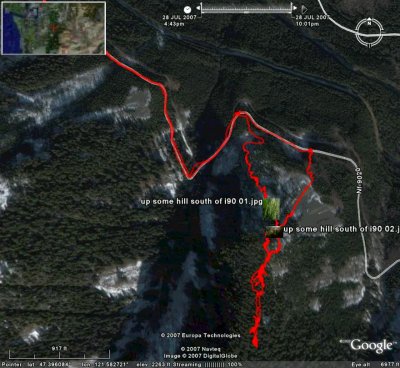
it was clear that something went amiss. On the way back down I checked with Mike a couple times to see if I was, according to Google Earth, headed for the road. (I went to the east to miss the rock climbing part of the up-trip.)
Mike: “I have good news and bad news. The good news is you’re really moving. The bad news is you already crossed the road.”
New tech in action, folks. It’ll work better next time. I’ll try it tomorrow. I gotta go back there to find my glasses which I hope are along the no-vehicle road.
Good part, though, is that the advice from BCCC (Bush Climbing Central Control) – in Boulder, no less – take that NORAD – was accurate. If I’d continued south on the ridge I was on, I’d have ended up in Oregon, not at a convenient logging road, navigable at night with the flashlight.
At home, Google Earth did find a logging road south of where I had been. Close examination showed it to be at the bottom of a vertical drop of some distance. Going back the way I came (well, sorta), was the thing to do.
All in all, a very satisfying day.