Squished Glasses found. Now all we need is a free country.

Those glasses that disappeared on the logging road were found. Not by me. I walked past them twice and didn’t see ’em the third chance, even. But a woman waiting for her husband said she had seen some broken glasses near the car.

We looked about a quarter mile down the road.

Apparently, the woman, her husband, I, and 1 ATV had been on the road in the previous 24 hours. The ATV did not miss the glasses.

The frames were pretty flattened. The lenses were laying apart in the rocky mud.

I wiped the lenses. A little ding in one was all the damage. But, then poly-carb lenses are the only way to fly.

The frames? Well, that’s what’s amazing. They were flat. Later, at home, I figured what’s the harm in trying to bend them back in shape. They did! The lenses are now a bit off kilter in the frames. The frames are still a little twisted and oddly shaped. On the whole, not quite good enough. But usable in a pinch.

Which got me to pinch-land.

The glasses didn’t come from Costco. They were insurance fluff from a regular eye doctor’s office. So there was no way I was going to get a dupe of the frames to drop the lenses in to. Well do I remember back when vision insurance started “covering” glasses. Oddly enough, the price of glasses went up at the time (for me anyway) by exactly how much insurance covered.

So I went to Costco to order some lenses to fit one of my many old frames (Costco, $60. Lenscrafters, $255.)

Experience has taught me to keep my current eye script on my Palm. Guess what? “In this state we can’t make lenses without a signed prescription.”

Huh? I can’t get glasses without doing some kind of Bulgarian Post Office thing (stand in 6 different lines to mail a letter)?

It’s not hard to imagine how such a disgusting law got passed.

Back when I was young there was much discussion of “socialized medicine” (what the AMA called a proposed government medical system to make it sound as bad as possible). The AMA was really, really intent on not having the government get in to medicine. They were, even then, a closed guild and wanted the organization that protected the guild to butt out – of everything but protecting the guild.

Time went by and, as so many other groups have found, the AMA, et al, found that there are some good points to having a central system enforce consumption of product from one vendor. All to protect the consumer, mind you. Having your own army, paid for by someone else, can sure beef up the bottom line. But, anyway, at least they have a product! One can probably think of some tax supported entities without a product at all.

Whatever. My mind went back to when I had to get glasses made in a hurry while in some odd place where no one in the country had a head shaped and sized like mine. Apparently, that was a free country, where ever it was.

I Went Bush Climbing

Bush climbing, not rock climbing. The latter’s never gonna happen, what with the volleyball knee and all.

What’s “bush climbing?”

Imagine a hill without a trail.

A steep hill.

With bushes.

And little trees and such.

Well, if you are a couple weeks from limping around and thinking you’ll never walk right again, and if you’re the kind of person who can’t seem to stay on a trail, and if you spy what must be a shortcut to who knows where, and if you’re at the end of some side road up some hill, but don’t want to just wander on down and find somewhere else to go, what do you do?

You look up the hill, pretend that there are some clear spots in the foliage you can get through, pretend that the hill isn’t that steep, and you head on up.

And, after you’ve crawled up this thing by hauling yourself up grabbing huckleberry bushes, little Doug Firs, Cedars, and Vine Maples – yes, you too can dangle from some precipice, swinging your feet around looking for a place to put ’em while smiling encouragingly at the two huckleberries you’ve got your death grip on – then you can notice that the sun’s dropping behind McClellan Butte and you’re not in good shape.

Now what?

GPS to the rescue!

Well, anyway, even if it’s not really needed, I thought it would be fun to push the technology, sorta.

Called kids one by one. Scott called back ‘tween calls.

Me, “You at a machine?”

Scott, “Ha, ha. No!”

Me, “Ah, foo. I’m up a hill and want someone to find a logging road nearby for me.”

Scott, “I’ll check with Mike.”

Ring. Mike. In Boulder, CO, it turns out.

Back and forth, story and such.

Google maps.

Problem one: Google maps is unaccountably picky about how they take lat/lon. Order dependent. And they appear to take only a couple of exactly perfect formats. Takes a while to get straight. I’m kinda whacked so I don’t suggest a converter (as I know GM takes straight LA.decimal, LON.decimal. The GH615 shows DD.MM.thou format.). But, Mike figures it out.

Problem two: Mike says there’s a road north of me (where I came from) 400 yards. I’m thinking that’s a bit too near, but that 400 yards are horizontal yards, so maybe. Bothers me that at one time at the highest point I got to I can easily see 100 yards to the north. And that distance seems a small fraction of the horizontal distance I’ve covered.

Anyway, apparently, I must have either said the numbers wrong (by far the most likely possibility) or whatever format Mike found transformed ’em. Cause after I got back and generated this:

up_some_hill_to_east_of_mt_washington_01.kmz

which is too big for Google Maps, but shows this in Google Earth:

Google Earch snapshot of GPS track

it was clear that something went amiss. On the way back down I checked with Mike a couple times to see if I was, according to Google Earth, headed for the road. (I went to the east to miss the rock climbing part of the up-trip.)

Mike: “I have good news and bad news. The good news is you’re really moving. The bad news is you already crossed the road.”

New tech in action, folks. It’ll work better next time. I’ll try it tomorrow. I gotta go back there to find my glasses which I hope are along the no-vehicle road.

Good part, though, is that the advice from BCCC (Bush Climbing Central Control) – in Boulder, no less – take that NORAD – was accurate. If I’d continued south on the ridge I was on, I’d have ended up in Oregon, not at a convenient logging road, navigable at night with the flashlight.

At home, Google Earth did find a logging road south of where I had been. Close examination showed it to be at the bottom of a vertical drop of some distance. Going back the way I came (well, sorta), was the thing to do.

All in all, a very satisfying day.

Harry Potter – the new Star Trek

It occurs to me that Harry Potter will drive a future generation’s idea of where tech should go. Kinda like Star Trek has driven so much over the last 40 years.

Consider spells. They are rather like the search engine query interface. A few simple words and … magic.

But consider the problem from the spell’s point of view. The spell needs quite a lot of processing power. If your spell is to “freeze” something, do you mean the virus 1 meter in front of you? Or, do you mean your friend very near the general direction your wand is pointing? What’s the spell’s target and intention?

And consider the wand. Its purpose, apparently, is the help the spell figure out your intention. Is a wand the best thing to use?

Pointing works very, very well to indicate many things. But what if the “thing” is not a physical thing in space? What if you want to freeze a discussion? “Everyone stop talking for a moment” (everyone being, presumably, slaves – robots – machines). Let’s say you have a half dozen home-building machines sawing and hammering away on the new house. Pointing the wand and saying “freezzzaaam” is really, really ambiguous. Maybe you mean that the place in the house you’re pointing at is “just right”. But maybe you want all of the robots to stop working and take a lunch break or something. Or maybe they are all sorta working at cross purposes and need to stop and take a breath. Or maybe you’re putting another robot in the group and the others need to stop for a moment to regroup.

If things work out the way they apparently will, such things will be important problems to solve.

Consider, for instance, this simple example: Garbage trucks.

How do they work? Let’s assume low tech here. Nothing fancy.

The garbage guy is in a nice, comfortable cab, monitoring what’s happening with his truck. Maybe he takes the wheel in locations that are not handled by the auto-driver – like running through town to the freeway back to the dump, for instance. But, the truck does all the work while slowly prowling up and down the residential streets, flipping garbage cans’ contents in to the truck. The arm that grabs the cans can see the cans, grab ’em, empty ’em, and put ’em back on the curb. Not a big deal. Especially late at night or early in the morning. Slowly driving the truck down these streets really amounts to dodging any kids there may be. Late night, early morning hours makes that job pretty easy, too.

So the operator, the garbage man, is a monitor, a watchman. He may occasionally need to get out to unjam something. But on the other hand, he’s more like the brakeman on a train, isn’t he?

Which puts him back at the shop rather than in the cab. He’s monitoring a dozen trucks. When he has a problem with more than one at one time he simply stops the others while each problem is dealt with. Freezing a bunch of trucks is troublesome in traffic but not on the garbage-can streets.

So, when the trucks need to go in traffic, do they flock together?

Anyway, what’s this guy in the shop going to point his wand at?

First Impressions of GPS

If history is any indication, the cell phone carriers will keep fumbling their location capabilities, so GPS just hasn’t hit the big time yet. Packages like this GH615 GPS watch could make a dent in things. Given the sub-$10 price of GPS chips, there’s a lot of room for interesting things underneath the mondo, expensive vehicle stuff that’s going out the door now. Oh well.

What I’ve found is that GPS is not as accurate as one would like. Tracks in the city, but not in city-canyons, look like this image from Seattle’s international district:

GPS track in Chinatown

The wandering lines are when I was walking. Stand in one place and there are lots of random squiggles. Stop at a light: squiggles.

It’s funny how the lines can have you on the correct side of the road, going and coming. But they go all fuzzy when you’re walking around. I figure the bigger the highway, the broader the sky view. Walking, you usually have some obstruction nearby, solidly blocking at least direction.

Trees are a major obstruction in this neck of the woods. Tracks from the driveway are regularly separated by 60 feet, north/south. The driveway runs east/west for about 400 feet and is not 60 feet wide. But then, the driveway has no clear view of the sky except straight up and some obstructed views east and west. Hard to triangulate given that narrow an angle to work with.

Let’s mention the feeling you get when you see a track on Google Maps or Earth (or whatever). Fascinating. Consider this snippet:

GPS track inside Issaquah Costco

Unlike the Issaquah Safeway, which appears to be GPS shielded, the track inside Costco does a cartoonish, but reasonable rendition of the track I took inside the store that day! Is that the effect of the skylights in the store?

Back in the mid/late ’80s, when I calculated that it would cost $3 a day to video record everything you did, 24/7, it’s been intriguing to consider the implications of such recordings.

Here’s one that these GPS tracks brings to mind: They bring the past to mind. Note that there are two squigglies in the street as I was going in to Costco. Yeah. There was a long line of cars turning left, so I had to wait once way back and wait again ’cause the light turned before I could make the turn. Now, being reminded of that day-to-day, background item is not important, but consider how such reminders can trigger the brain to remember more important things. Or, consider how such small things can simply take you back to the past.

Or take another angle: An Issaquah traffic engineer might find information in a gob of GPS squigglies from his turf. One must presume that the traffic guys find the Metro/Seattle bus tracking interesting. Speaking of which: that screen shot was done deep in to a Friday night. What’s with the two buses on an off-street?

Hmmm. Cut. Cut. Cut. Thinking for this blog entry is veering in to product idea land. So it’s time to break off and go to B2.

A new toy: GH615B GPS watch

Background: This is my first GPS device. I wanted a device that I could use to geo-code pictures and to track hikes. It needed to internally store several hours of very frequently sampled locations. And it needed to get those locations back to the PC later.

There is a $100 device that reviews say has good PC software for geo-coding pictures. But, though the GH615 is more expensive, $140, it:

  • uses the Sirf III chip (which the reviews all say is a good thing)
  • is in a watch form factor rather than needing to be stashed in the daypack or something.

A guy at Semsons was very helpful and seemed to know whereof he spoke. He leaned me toward the $100 device just a hair, but didn’t say anything to stop the watch-form-factor being the deciding factor. The 8 hour battery life on the GH615 was reported to be just at the edge of what I could use. The $100 device had much, much longer battery life.

So there it was. I placed the order.

Got the watch in a couple days.

Let’s get to the bottom line:


Good:


Watch form factor.

Display is handy (other devices I considered have no display)

Bad:


PC software (version ?) should not have been released. It’s that bad.

Design flaws in storing and sending the location data to the PC.

Cable is a custom job and apparently not robust.

Very version 1 product.


Let’s be frank. I have somehow allowed myself to be sucked in to writing software to support this device, handle GPS information in general, and to geo-code jpg’s in particular … for 2+ weeks … straight … with not a lot of sleep. Fun, perhaps, and behavior that’s a bit of a throwback to my 20’s. But … Well, this product is not something that says, “Oh wow! This is cool.”

The PC software:

There is reason to believe that other versions of this device come with a newer version of the PC program (on a support forum someone told of using a feature not in my version of the software). But the US GlobalSat web site does not have newer versions of the PC program or firmware. The parent, Taiwan site didn’t resolve DNS when I first tried to use the PC software. It does now – AND they have updates for the PC software and watch firmware. I just tried the updated PC software. It has not fixed the key problem of the original software: very unreliable communications with the watch. Some of that problem could be the watch firmware, but COM port monitoring tells me that there are obvious bugs in the PC software. And the new version does not appear to be substantially different from the version on the CD. So I just don’t know what to think. One thing: If I take a chance and try to update the watch’s firmware, I will surely log the COM port data so that I’ll not need to use that PC program again!

Let’s let that rest a moment.

So, why did I “go away from the world”? Well, for starters, I wrote a Windows (probably portable) program, gh615_grab that as reliably as possible gets the locations back from the device to the PC. This is no mean trick. The watch and/or serial/USB cable and/or Windows driver spew garbage often enough. The protocol would make any weak engineer from the ’70s comfortable. The watch’s reactions to unexpected input are not robust. Etc. You get the picture.

The watch firmware has some version 1 issues – minor UI things and such. But nothing a v2 couldn’t fix. Examples:

You need to explicitly put the watch in a PC communications mode to transfer data other than the user information.

A button lets you “page” between various views. One view is the stopwatch/clock. That view has several variants that the up/down buttons cycle through. But when the main view is changed, the current stopwatch/clock variant showing is forgotten. Next time you see the stopwatch/clock view, it reverts to showing the stopwatch.

When you “download” (Really, “download” is the word they use. They mean “Copy to the PC”.) the “trackpoints” or “Activity Info” or “Files” or “Training Data” or whatever the location data is called, you don’t get all the locations from the watch! On the watch, you must first go to the stopwatch/clock view, push the ESC button, “Reset Training Data and Save? | Yes”. That zeros the stopwatch, too.

Overall, though, the watch has a pretty reasonable UI. Watches don’t have a lot of buttons, so they are hard to do UI for. This one is almost consistent, button-push-safe, and easy to grok. They did a pretty good job with their 6 buttons.

And the watch buttons are physically great. They are big, take a strong push (no accidental pushes), and give very clear tactile feedback.

The screen is fine. Only the power button lights the backlight. (Another flaw, since the buttons don’t push too easily.)

I’m not clear why there is a compass function on the device. It doesn’t work. It probably should work. But until they get it working, it should not be there. The compass often showed north to be due west in my testing. But mostly it was random. Finding true north is not hard, except in a whiteout. Walk 30 or 40 feet in one direction. Look at the direction of the graphical tracks and compare it to N on the screen.

Anyway, I built up a page of QA-like notes on things wrong with the device and PC program. But why bother? In the end, I’ve gotten it running for my purposes.

Or have I?

Let’s see what a couple weeks of time on a critical component has done:

Cable on the way south

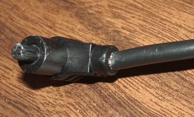
Since this cable is not something you can pick up at the corner computer store, I’ve put in a trouble ticket on it. We’ll see what happens. They should not have used a custom cable. Doubtless, they used the funky 4-pin plug for watertightness reasons. But they should have provided a solid, robust dongle that had the 4-pin on one end and some standard socket on the other.

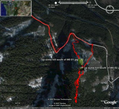
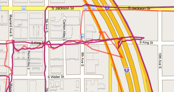
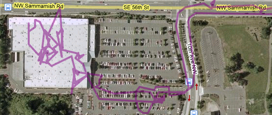
Speaking of flaws, here is a typical, but big one: If you stop the stopwatch, the watch stops remembering GPS locations. Fair enough. It’s clear after some dinking around that running the stopwatch is what causes the watch to remember locations. But, the kicker is that the watch does not remember the time associated with each location. Instead, it remembers how much time has passed since the previous location acquisition, the “delta” in engineer-speak. Storing time deltas can take significantly less memory than storing the absolute time, so such logic makes good sense. The problem is that when the stopwatch is not running, time does not pass. Pause the stop watch and you don’t know it, but you have just lost all ability to use subsequent location data to geo-code pictures.

Too, the “deltas” are returned to the PC in 16 bit 10ths of a second. Locations are not stored when the watch can’t get a satellite fix. So, if you go inside, or hike up a narrow canyon for a bit less than a couple hours, the delta value wraps or pegs (I’ve not checked) and all subsequent times are ambiguous.

That this device is flawed is really sad. The watch form factor and the inherent simplicity and utility of it should make it a very, very compelling gizmo. Yes, I’ve heard comments about it being a huge watch, but it’s very light and surprisingly quite wearable. But then, I’ve always tended to go with hefty watches.

GH615 with other watches

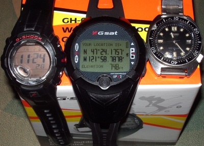
Anyway, given that my watch is serial number 344, what can I expect?


Update:

To fix the cable, they wanted the whole unit back!

I asked why.

“it is company policy…”

It’s not such a good day, anyway, but I take back my post on their forum about feeling sorry for this:

Top Google search for GH 615 GPS watch

I’m peeved, but will probably cool down sometime.

I blame global warming

Google Earth sees the future through true-believer eyes:

Hillsboro Ohio in the far east


Spoiler:

.

.

.

.

.

.

.

.

.

.

.

.

.

.

.

.

.

.

.

.

.

.

.

.

.

.

.

.

.

.

.

.

.

.

.

.

.

.

.

.

.

.

.

.

.

.

.

.

.

.

.

.

.

.

.

.

.

.

.

.

Someone geocoded a bunch of Ohio towns with positive longitude values.